
Auckland’s geological story begins nearly 300 million years ago, when the region formed part of the eastern edge of the Gondwana supercontinent.
As the ancient Pacific plate subducted beneath Gondwana, sandstones, mudstones, and volcanic rocks accumulated to form the basement rocks still found beneath the city today. Around 105 million years ago, continental rifting split Gondwana apart, opening the Tasman Sea and Southern Ocean and creating the largely submerged continent of Zealandia, of which New Zealand forms the most prominent exposed portion.
After a long period of relative quiet, northern New Zealand became tectonically active again around 25 million years ago as the Pacific Plate began subducting beneath the Australian Plate. This produced two volcanic arcs: the Waitakere Volcanics to the west, and the Coromandel Volcanic Arc to the east, active until around 2 million years ago. The eroded remnants of both are visible from Auckland today as the Waitakere and Coromandel ranges on the western and eastern horizons respectively.
Concentrated area of magma rise
Liquid magma, created from melting upper mantle rocks, can travel through cracks or weak spots in the Earth’s crust. Like paint bursting from an old tube, magma will find the easiest route to erupt through the surface. As the “ducts” (conduits) of previous volcanoes become blocked by solidified magma, it is unlikely that eruptions will recur in the same spot.
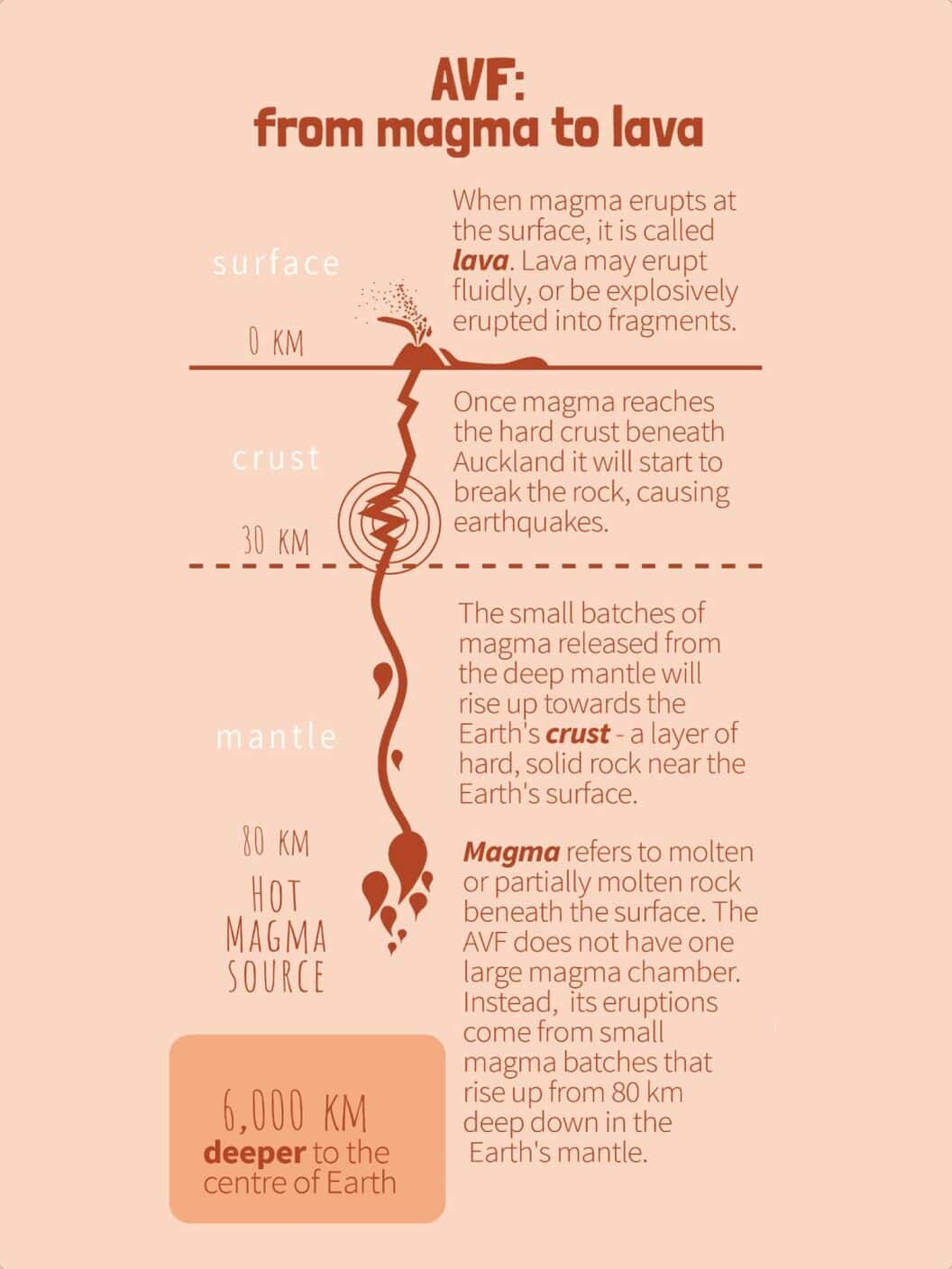
By analysing how fast seismic waves travel through the mantle and crust under Auckland, scientists have detected a low velocity zone in the mantle (70-90 km deep). We interpret this to be a hot partially molten area of rock that is responsible for the volcanic activity in the Auckland Volcanic Field. These pockets of melt produce basaltic magma that can sometimes travel to the surface and cause an eruption.
A region full of volcanic fields
The Auckland Volcanic Field is one of six intraplate monogenetic volcanic fields that have erupted across the northern North Island over the past 10 million years.
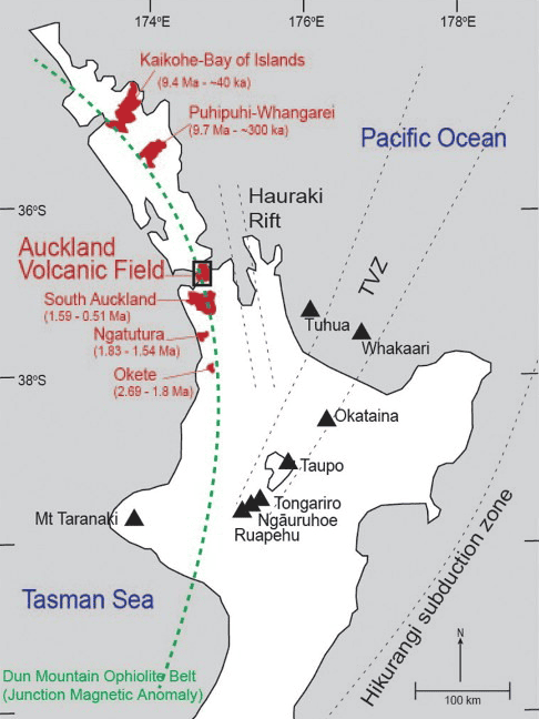
The four fields in the Auckland region: Okete, Ngatutura, South Auckland, and Auckland itself, are spaced at roughly 35 to 40 km intervals and become progressively younger to the north.
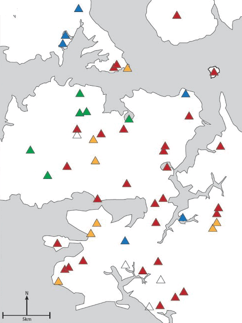
- 0-49,000 years ago
- 50,000 to 99,000 years ago
- 100,000 to 150,000 years ago
- 150,000 to 200,000 years ago
- as yet undated
This pattern means we can rule out a simple hotspot explanation and instead suggests that the mantle source is migrating northward. However, this does not mean that the locations of eruptions within each field progresses northward. For example, in the Auckland Volcanic Field, the oldest eruption at Pupuke is located close to the youngest eruption at Rangitoto. Our research has not detected any patterns in eruption location with time in Auckland.
It’s rocks!
Most of the Auckland Volcanic Field is made up of basaltic rocks. Each volcano in the Auckland Volcanic Field represents a new batch of basaltic magma which travelled from its deep source, through ~250 million-year-old compressed sandstones known as greywacke and younger ~25 million-5 million-year-old marine sedimentary rocks in the subsurface before erupting.
Eruptions in the Auckland Volcanic Field are likely to range between quiet lava flows and fountains of lava to explosive eruptions caused by phreatomagmatic activity (when magma interacts with water). Slightly more than 80% of eruptions in the Auckland Volcanic Field began with a ‘wet’ explosive eruption, where the ascending magma interacted explosively with groundwater and/or surface water.
Keep reading
More about this topic
-
Volcanic landforms and eruption deposits
Why Tāmaki Makaurau’s landscape looks the way it does
-
How distributed volcanic fields work
Instead of most eruptions taking place at one central vent at the summit, eruptions in volcanic fields usually take place from a new vent in a new location.
-
Frequency of eruptions
The chance of a future eruption is roughly 10% over the next 50 years, based on a gap of about 500 years between eruptions over the last 60,000 years.
-
Human geography
The impact of humans on Tāmaki Makaurau Auckland
-
Hochstetter's map
The 1859 map of the Auckland isthmus and its volcanoes, and who really drew it